 10. Bubbly Creek
Location: Chicago, Illinois
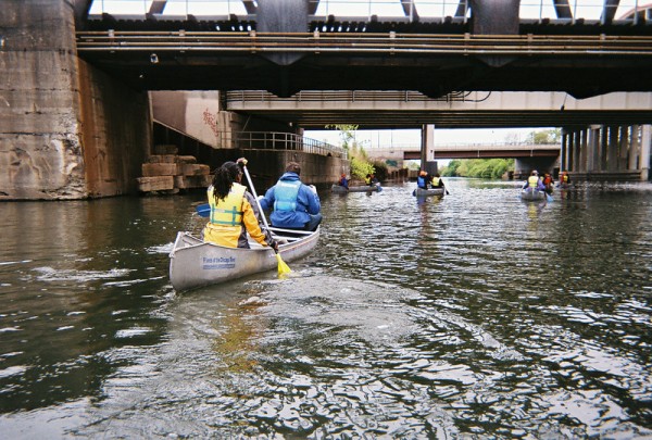
During the 19th century the scene of the Bubbly Creek was no less than as if a war took place nearby. The section towards the South Branch was named as Bubbly Creek. Originally the area was a wetland, but channels were dredged and the South Fork became an open sewer line for the local stockyards, especially the Union Stock Yards. On top of all this, slaughter houses in the adjoining areas started to dump large amounts of waste, such as blood and entrails. Naturally due to the presence of so much blood and animals parts, chemical reactions took place and water actually started to bubble with methane and hydrogen sulfide, hence the name” Bubbly Creek”. Towards the end of 20th century, large number of bloodworms found their home here. They fed on the thick mass of rotting blood which is located on the river bed. Oxygen depletion made the Bubbly Creek hypoxic and the creek remains highly toxic and the surrounding area is full of a rancid smell pushing the locals away from the creek.
9. Centralia, Pennsylvania
Location: Columbia County, Pennsylvania
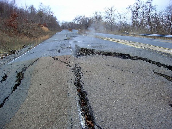
The town was originally a coal mining area but was destroyed by a fire that left the town uninhabitable. In 1966, Centralia went out of the mining industry. The town which once proudly held seven churches, five hotels, twenty-seven saloons, two theatres, a bank, a post office, and fourteen general stores was made uninhabitable by a fire in 1962 which ignited in one of the mines below the town. The reason for the ignition is not fully understood however one theory suggests that the event occurred in May of 1962 when the Centralia Borough Council hired five people to clean up the town landfill, which was located in an abandoned strip-mine pit. The men did not extinguish the fire correctly and it spread through a hole in the rock pit and then into the abandoned coal mines beneath Centralia. In the late 1960s and 1970s dozens of town residents were hospitalized for carbon monoxide poisoning. Sink holes began to appear in the city limits and steam ports were often reported.
The population of the town saw ups and downs over the years. It ranged from over 1,000 residents in 1981 to 12,000 in 2005 to 9,000 in 2007. Centralia is one the least populated town of the state, one reason being that in 1984, U.S government allocated funds for relocation of the people and most of the people living there opted for a buyout implying that the government took ownership of the town. In 2002 the U.S. Post Office revoked Centralia’s zip code. There are little homes left in the area and the area is filled with sign of carbon monoxide poisoning and even steam can be seen at times from distance.
8. Dallol
Location: Afar Region, Ethiopia

Dallol is usually referred to as a ghost town with very few structures, most made of salt blocks, with travelling means of the old days such as camel caravans etc. located in the Administrative Zone 2 of the Afar Region in the Afar Depression, the area once had a railway back in 1928 constructed from the port of Mersa Fatma in Eritrea and then to a point 28 km form Dallol. However, after World War II it was removed by the British administration, as international trade routes had expanded. The area is also home to a volcano which n 1926 erupted leaving behind a 30 meter wide crater and forming geological hot springs. There are also deposits of salts and Dallol Co. of Asmara even sold salt from 1951 to 1953. One more attribute of the area is the temperature of the region. It is usually hot reaching upto 115 F. Dallol is one of the most remote regions of the world. The adjoining areas are hostile making it difficult for visitors. Many impressive hot springs do exist at Dallol, giving a stunning view of yellow and red hydrothermal deposits. However, Dallol lies in northeastern Ethiopia close to the disputed Eritrean border. Due to this reason, along with some hostile Afar tribesmen, make the area dangerous and several armed attacks on tourist convoys have occurred in recent years.
7. Hanford Site
Location: Hanford, Washington State

The weapons production reactors at the Hanford Site were decommissioned at the end of the Cold War, but the manufacturing process has left behind 53 million gallons (204,000 m³) of high-level radioactive waste. The waste remains at the site and it represents two-thirds of all high-level radioactive waste in the U.S. The Hanford Site is the most contaminated nuclear storage facility in the nation. It is also the focus of the United States largest environmental cleanup. The Hanford Site occupies 586 square miles (1,518 km2) and the Columbia River flows along the site for approximately 50 miles.
The site is bordered on the southeast by the Tri-Cities, a metropolitan area composed of Richland, Kennewick, and Pasco, which is home to over 230,000 residents. This area of Washington becomes warm in the summer and extra firefighters are stationed in the surrounding communities in case of toxic brush fires.
More than 70,000 containers of this waste (sometimes referred to as suspect TRU waste) were stored under a layer of dirt in the in the 1970’s and 1980’s, in the 200 Area Low-Level Burial Grounds of the Hanford Site.
6. Dzerzhinsk
Location: Nizhny Novgorod Oblast, Russia
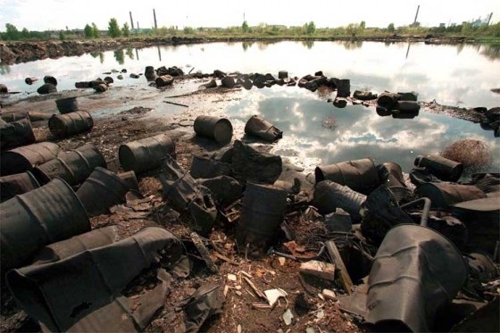
The population of Dzerzhinsk is around 250,000 people. The area is one of the main centers for chemical processing in the Russian Federation, producing synthetic ammoniac, fertilizers, and herbicides. In 2008, Dzerzhinsk had 38 large industrial corporations, which export goods all over the world. The area produces around 1,000 different varieties of chemical products. According to the 2007 ranking of the NGO Blacksmith Institute, Dzerzhinsk is one of the most polluted cities in the world, ranking as more deadly than Chernobyl. The areas water supply is contaminated with many toxins and the phenol levels are reportedly seventeen million times the safe limit.
Some estimates have the life expediency numbers in Dzerzhinsk very low for Russia. The 2007 NGO Blacksmith study actually suggested that the life expediency of Dzerzhinsk in 2006 was only 42 years for men and 47 for women. However, the Dzerzhinsk City Administration asserts that the Blacksmith Institute report is false and according to the city Health Department 2006 report, the average life expectancy in the city was 64 years. The Dzerzhinsk’s environmental agency has estimated that almost 300,000 tons of chemical waste was dumped in the city between 1930 and 1998. The area was until recently closed to tourists.
5. Dharavi
Location: Mumbai, India
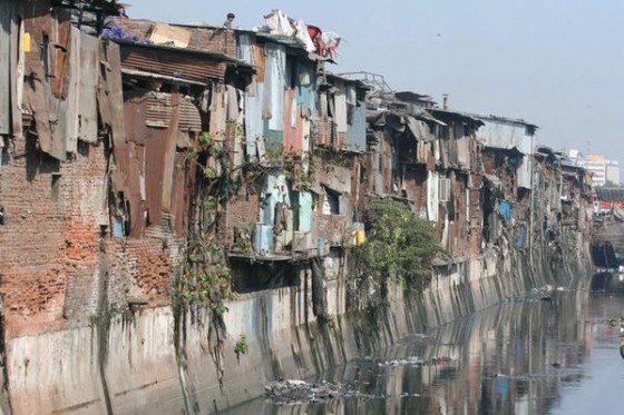
The population of Dharavi is thought to exceed 1 million people. Dharavi is home to many traditional pottery and textile industries. The area also supports a large recycling company, processing recyclable waste from parts of Mumbai. However, wages are very low and living conditions are bad. Public health is horrible in the slum. Toilets are scarce and a 2006 study found that there was only one toilet per 1,440 Dharavi residents.
Mahim Creek is widely used by locals for urination and defecation, leading to the spread of many contagious diseases. The area also suffers from problems with inadequate water supply. The stench of Dharavi is horrible and many open sewers exist in the area. Dharavi was featured in the 2008 award winning film Slumdog Millionaire. The Indian government has released plans for a redevelopment project, which aims to transform the giant slum into a self-sustaining urban community.
4. Linfen
Location: Shanxi Province, China
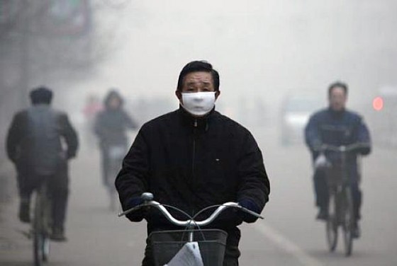
Thousands of iron, steel, and coal plants populate the city of Linfen. The Chinese citizens who live in the city are forced to wear face protection throughout the day. It has been reported that at times you can’t even see your own hand in front of your face because of the thick pollution and headlights are constantly needed. The people of Linfen have become accustomed to being covered in coal soot and airborne pollution every time they leave their homes. British experts have even compared the effects of the pollution to that of a nuclear power plant disaster. However, four million people live in the immediate vicinity of Linfen.
In the past couple years Beijing officials have ordered strict policy changes, but as one plant is targeted and shut down, another one opens up illegally. A child with a repertory illness has a life expediency 10 years shorter than average. The Fen River near Linfen, the source of drinking water for millions, is an open sewer. International studies have also suggested that the rate of arsenic poisoning is very high in the Shanxi province and life expediency is lower than the Chinese average.
3. Room 39
Location: Pyongyang, North Korea

Room 39 is a clandestine government organization located somewhere in North Korea as nobody knows for sure where it actually exists. It is said though that maybe it might be operating from Pyongyang. Room 39 was established in the late 1970s and has been described as the head of North Korea’s “court economy” centered on the Kim family and being a slush fund. Room 39 has been accused of conducting illegal activities such as drug smuggling, weapons sales, sale of nuclear weapons secrets and money laundering. U.s accused Room 39 that they sold military technology so that North Korea can obtain foreign currency; naturally North Korea denied the accusation. It is also one of the most dangerous locations in the world, unless you are a high ranking North Korean military official.
2. Mogadishu
Location: Benadir Region of Somalia
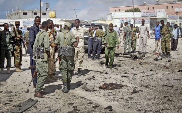
Somalia as a country is one of the most unstable region of the world. The country is struggling while the warlords fight each other to the death to gain power. Mogadishu is the largest city in Somalia and the nation’s capital. Until very recent (2006) Islamic Court Union ceased control of the country but the Ethiopian military invaded in an attempt to sieze power. Mogadishu has been the scene of bitter warfare and devastation caused by fighting between the Ethiopian and Somali governments, and Islamist guerrillas. Since there is no stability in the region, it invites foreign predator, unidentified vessels poach an estimated $450 million in seafood from Somali waters annually. The country is also used as a dumping site for nuclear waste material. In 2009 there something unusual happened, a string of suicide bombing took place killing thousands. Things have been downhill ever since and the place is not suitable for tourists either.
1. Cité Soleil
Location: Port-au-Prince, Haiti
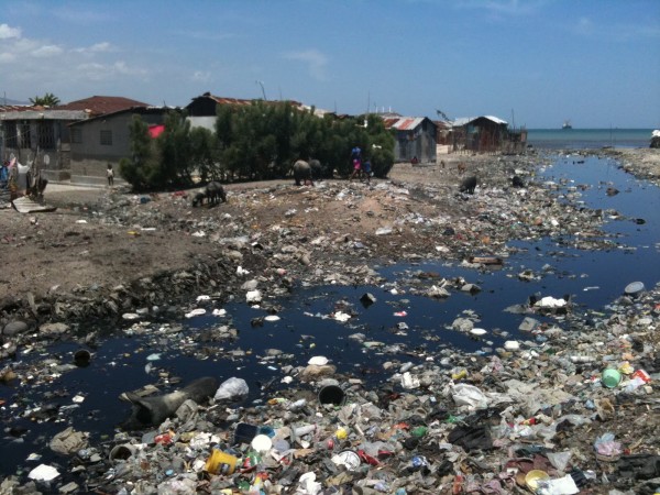
Cité Soleil is a densely populated shanty town located in the Port-au-Prince metropolitan area of Haiti. The town has an estimated population of 200,000 to 300,000. Not only is it one of the largest slum but also one of the most dangerous place on earth. There are no sewers or stores or electricity and even the police is a handful in 2004 UN forces invaded in order to take control of the violence but they were not successful. Armed gang members roam the streets and murders, kidnappings and rape are common to that area. On top of all this in 2010 an earthquake hit 16 km left of the town and left the town struggling for its life. It killed over 230,000 and left 1 million without home. It took over 14 days for relief to reach the slum as the roads were destroyed. Crimes reached record time high during this time. Cité Soleil is home to mostly children and young adults. Few residents survive past the age of 50 and most die from disease, including AIDS, or violence. The town lacks basic facilities and is polluted. Foreign travelers are specially targeted for ransom money.