Bangalore, Shruthi H M, Nov 21, 2013, DHNS: Students at a school here gave their teacher the shock of his life when they drew the India map without the Pakistan-occupied Kashmir (PoK). The teacher further panicked when students insisted it was the correct representation of India as per the guides and the textbook.
Lifting maps from the Internet and publishing them without verifying their accuracy have led to serious errors creeping into textbooks and guides. Publishers, who must take the permission of the Survey of India – the Central government agency in charge of mapping and surveying – before publishing maps, often fail to do so as they find it more convenient to lift them from the Internet.
S Sathish, who teaches social science at Presidency School, said he first learnt about the blunder when students drew Kashmir without PoK, in a unit test. “If this continues, after a few years, students will forget the other part of Kashmir.
Publishers should be careful. As it is, many foreign countries have been misrepresenting our borders on the Internet,” said Sathish, highlighting the lack of stringent rules in monitoring the maps published.
A senior regional officer in the Survey of India, who took a look at the maps, confirmed they were erroneous.
“If the map is for representation only, they should print that at the bottom of the map. Even in such a case, however, the map has to resemble the actual map.” When contacted, the editorial team of S Chand Group promised to replace the maps in the next edition of 2014-15.
The publishing house also shared with Deccan Herald the revised maps to appear in the next edition. A member of the editorial team said, “We generally use the atlas of our own publication to maintain accuracy. But it is not easy to access historical maps, in which case we depend on some websites. From now on, we will stop that practice. If at all we have to take it from a website, we will mention the link below the map for reference.”
Lack of awareness
Lack of awareness drives publishers, especially of local guides, to pick random maps from the Internet. They do not see anything wrong in lifting from the Internet or even scanning handwritten copies of maps. In another instance, an SSLC guide of a publisher in Bangalore misrepresented the country’s boundaries in its India map. When contacted, Shekhar Reddy, the owner of M C Publications, told Deccan Herald the maps in question were scanned from a handwritten copy.
Department of State Education Research and Training Director, H S Rama Rao, stressed that publishers, big or small, must take the permission from the Survey of India before publishing maps of India. “For the State textbooks, too, the Karnataka Textbook Society takes permission of the Survey Department before publishing a map.”
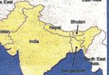
Erroneous maps
The maps, in which Kashmir was not properly represented, were found in class VI and VII social sciences textbooks published by S Chand Group and prescribed by ICSE schools.
In the class VII book, PoK has been represented as part of Pakistan in explaining the Indian subcontinent. Titled ‘Extent of Indus Valley Civilisation’ in class VI book, the diagram shows the geographical extent of the Indus Valley civilisation in green, next to the current map of India, represented in yellow. PoK is, however, missing from this part (representing India as of today).