Hyderabad: When Satheesh C Shenoi did his PhD in physical oceanography in 1984 from the Cochin University of Science and Technology, little did he imagine that 25 years later he would head an institution pioneering in Tsunami research and warning in India.
The word tsunami was totally unheard of to the public and its description used to be just a para or two in our course. A research paper proposal on Tsunami would sure have attracted lot of laughter then,” says Dr Shenoi, director of INCOIS–Indian National Centre of Ocean Information Services–in Hyderabad.
This scenario changed from December 26, 2004 when the terrifying waves from Bay of Bengal introduced us to a natural disaster till then only identified with Japan. Giant waves of up to five metres lashed at towns and villages on the shore with sea water inundating up to one km inland.
An estimated 16,000 people died on that day in Andaman and Nicobar Islands and the south-east coast especially Tamil Nadu. Reason being absence of a Tsunami monitoring and warning system.
Now, a decade after, INCOIS presents a story of a country clueless about such a natural disaster to becoming an authority on tsunami warning catering not just to India but to whole of the north Indian Ocean region.
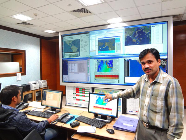
Set up in 2007 here under the Ministry of Earth Sciences it has a ground station (with a radar receiving data from various satellites including Oceansat-2) and the Indian Tsunami Early Warning Centre initially operating 24×7, which initially started in 2005.
INCOIS partners with several top institutions like ISRO, IMD, Survey of India and National Institute of Ocean Technology in its endeavour.
Six tsunami buoys–four in Bay of Bengal and two in North Arabian Sea–are measuring the water levels every hour and ceaselessly in case of a fluctuation. 36 tide-gauge stations along the Indian coast and 17 seismometers located across the country help in detecting a Tsumani. Data from across the globe is also accessed and assessed.
“Information from the satellites, buoys, seismometers is collated to predict a Tsunami and depending on magnitude the situation would be categorised as Warning, Alert, Watch,” Shenoi says.
The centre has devised over 5,000 model scenarios of tsunami and can send out a bulletin and alerts to the specific wave-prone areas within minutes of an earth-quake in the ocean – the cause of Tsunamis.
The centre also has contact info of the government machinery and locals residing in buildings in the vicinity of the sea.
ITEWC has been correctly predicting Tsunamis like in March 2011 on Japan and in April 2012 when it sent out Warning to a few islands of Andaman and Nicobar.
“A devastating tsunami might not occur again in our life time but we could not have remain unprepared (after what we witnessed in 2004),” Shenoi says.